The morning light catches the dry savanna grasses of Gili Lawa Darat, painting the undulating hills in shades of ochre and olive. A cool breeze carries the scent of salt and sun-baked earth across the bay, where the still water reflects the sky like polished glass. Distant calls of seabirds punctuate the quiet, a prelude to the day’s unfolding drama of light and shadow across the Komodo archipelago.
Gili Lawa Darat: An Icon of Komodo National Park
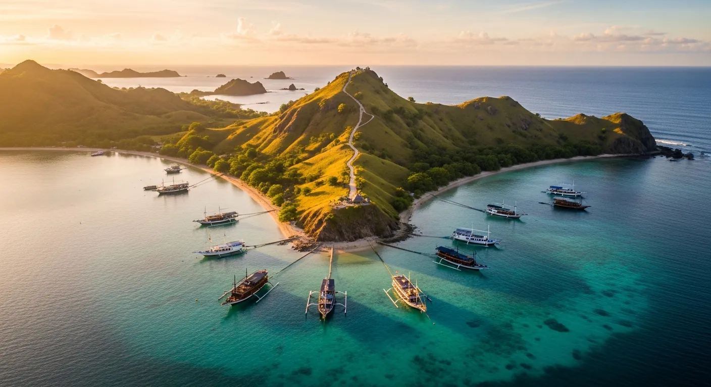
Gili Lawa Darat presents the quintessential Komodo National Park vista, an independent editorial guide to its iconic viewpoint hike, anchorage logistics, and the realities of a day trip from Labuan Bajo. This uninhabited island, situated in the northern part of Komodo National Park, East Nusa Tenggara, Indonesia, serves as a focal point for travelers seeking the region’s most celebrated panoramas. Its inclusion within the Komodo National Park area, a UNESCO World Heritage Site since 1991 under listing number 609, underscores its ecological and geographical significance. The island’s name, sometimes rendered as Gili Lawadarat in official Indonesian island lists, points to its singular identity within the archipelago. Geographically, Gili Lawa Darat faces a wide and deep bay on the northeast side of Komodo Island, a feature often described as resembling a fjord due to its dramatic, enclosed appearance. This unique topography contributes significantly to the island’s appeal, offering both visual grandeur and practical advantages for visitors.
Anchorage and Water Activities at Gili Lawa Darat
The fjord-like bay on Gili Lawa Darat’s northeast side provides a strategic and protected anchorage. This natural harbor is shielded from prevailing winds and waves, ensuring calm waters for boats and fostering ideal conditions for water sports. Kayaking and stand-up paddleboarding are popular activities here, with the tranquil bay offering a serene environment for exploration. Boats typically drop anchor in depths ranging from 10 to 20 meters, with good holding ground. The water temperature averages 28 degrees Celsius year-round, making swimming and snorkeling comfortable. Snorkeling directly from anchored boats often reveals vibrant coral formations and diverse marine life, though the primary draw remains the island’s terrestrial viewpoints. The absence of permanent human settlement on Gili Lawa Darat preserves its pristine character, contributing to the sense of isolation and natural beauty experienced by visitors.
The Viewpoint Hike: Sunrise and Sunset Perspectives
Gili Lawa Darat offers at least two main viewpoints, both highly popular for sunrise and sunset treks, providing distinct photographic opportunities depending on the time of day. The trails, while well-trodden, require moderate physical fitness. The ascent to the primary summit, often referred to as the sunset viewpoint, typically takes 20 to 40 minutes, covering an elevation gain of approximately 100 meters. Hikers should wear sturdy shoes, as the paths can be rocky and uneven, especially during the dry season from April to October when the ground is loose. For sunrise treks, starting the ascent around 5:00 AM allows ample time to reach the summit before the first light breaks over the eastern horizon, usually between 5:30 AM and 6:00 AM. Conversely, sunset trekkers typically begin their climb around 4:30 PM to position themselves for the golden hour, which commences around 5:30 PM, with sunset occurring between 6:00 PM and 6:30 PM.
Understanding the Trails and Photographic Considerations
The trails to Gili Lawa Darat’s viewpoints are generally clear, marked by the passage of countless previous visitors. However, local guides often accompany groups, providing assistance and ensuring safety, particularly during low light conditions. The main trail to the higher viewpoint offers a 360-degree panorama, encompassing the “fjord” bay, Komodo Island, and the expanse of the national park. Photographers should consider bringing wide-angle lenses to capture the expansive landscapes and telephoto lenses for distant island formations. During the dry season, the hills are covered in golden savanna grass, offering a stark contrast to the azure waters. In the wet season, from November to March, the hills transform into a lush green, providing a different aesthetic. Drone photography is permitted within Komodo National Park, subject to park regulations and permits, offering aerial perspectives of the island’s unique topography.
Logistics of a Day Trip from Labuan Bajo
A day trip to Gili Lawa Darat from Labuan Bajo typically involves a speed boat journey of approximately 1.5 to 2 hours, covering a distance of about 45 kilometers. Longer, traditional phinisi boats may take 3 to 4 hours. Most organized tours depart Labuan Bajo between 6:00 AM and 7:00 AM, aiming to reach Gili Lawa Darat by mid-morning. These tours often combine the Gili Lawa Darat viewpoint hike with other popular Komodo National Park destinations, such as Komodo Island or Padar Island, and snorkeling stops at Manta Point or Pink Beach. The cost of a shared day trip from Labuan Bajo can range from 800,000 IDR to 1,500,000 IDR per person, excluding Komodo National Park entrance fees, which are approximately 250,000 IDR for foreigners on weekdays and 375,000 IDR on weekends. Private charters offer more flexibility, though at a higher cost, starting from 8,000,000 IDR for a full day.
Planning Your Visit to Gili Lawa Darat
Visitors should pack light, breathable clothing, a hat, sunglasses, and reef-safe sunscreen. Sufficient water is crucial for the hike, especially given the tropical climate, where temperatures often exceed 30 degrees Celsius. While some tours provide snacks and lunch, carrying additional provisions is advisable. The best time to visit Gili Lawa Darat is during the dry season, from April to October, when the weather is consistently sunny and the seas are calm. However, this is also peak tourist season, so expect more crowds. The shoulder months of April, May, and October offer a balance of good weather and fewer visitors. Remember that Gili Lawa Darat is an uninhabited island; there are no facilities such as restrooms or shops. All waste must be carried out. Respecting the park’s regulations, including staying on marked trails and not disturbing wildlife, is paramount for preserving this unique ecosystem.
Gili Lawa Darat in the Wider Komodo Archipelago
Gili Lawa Darat is an integral part of the East Nusa Tenggara island geography, located within the expansive Komodo National Park. Its position in the northern reaches of the park places it in proximity to other renowned islands like Komodo Island itself, home to the Komodo dragon, and Padar Island, famous for its tri-color beaches and panoramic viewpoints. The island’s geological formation is volcanic, characterized by undulating hills covered in savanna grasses and occasional patches of dry forest, typical of the Lesser Sunda Islands. The prevailing winds, largely from the southeast during the dry season and northwest during the wet season, shape the island’s vegetation and coastal features. The marine environment surrounding Gili Lawa Darat is part of the Coral Triangle, a global center of marine biodiversity, boasting over 1,000 species of fish and 350 species of coral. The nutrient-rich waters support a complex food web, making snorkeling and diving in the broader Komodo National Park a world-class experience. The nearest major administrative center is Labuan Bajo, on the island of Flores, which serves as the primary gateway for all Komodo National Park explorations.
List of islands of Indonesia
Wikidata: Gili Lawa Darat
Gili Lawa Darat offers an unparalleled perspective on the wild beauty of Komodo National Park, an experience that transcends a mere hike to a viewpoint. It is an encounter with the raw power and serene majesty of East Nusa Tenggara. For more insights into planning your journey and exploring the wonders of this iconic region, continue your research on gililawadarat.com.